 photo taken at the oldest bridge in Regensburg, Germany..the Steinerne Bridge.
Showing posts with label location. Show all posts
Showing posts with label location. Show all posts
Sunday, June 28, 2009
Sunday Escapades in Regensburg, Germany
Sunday is almost Over again. I hope you had a great one! Yes, I am! Although I'm feel very tired because of having not enough sleep for two days now, I still manage to smile as we went to the Buergerfest in Regensburg, Germany. I am sharing a picture now..feel free to visit my other sites or more photos! Have a great week ahead!
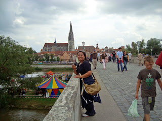 photo taken at the oldest bridge in Regensburg, Germany..the Steinerne Bridge.
photo taken at the oldest bridge in Regensburg, Germany..the Steinerne Bridge.Monday, February 25, 2008
Shopping..Shopping and more Shopping!!
I said to myself that I don't go shopping anymore..but I love shopping..i'm a normal person esp. a woman who loves shopping. I believed there is no woman who don't love shopping..After we went to Walhalla today, we proceed to Donau Einkauf Centrum, in English Danube Shopping Center..it's a German word anyway..
At this time there are a lot of WSV- Winter Schluss Verkauf..or this so called in English Winter Closing Sale..since winter is fast ending.. I did not knew this before..now that I know this one, I usually buy at this time where you can have till 90% discounts esp. on clothes..such a good deal..got some evidence that I was there today!! See you tomorrow dear friends..thanks for always visiting me here!!I really appreciate it..
 one of my favorite shop..bought some clothes here today
 my other favorite shopping shop..guess these two shops will pay me for
advertising their shops in my site...just kidding!!
 I love this white jacket..might probably wait
when it will be on sale next time
At this time there are a lot of WSV- Winter Schluss Verkauf..or this so called in English Winter Closing Sale..since winter is fast ending.. I did not knew this before..now that I know this one, I usually buy at this time where you can have till 90% discounts esp. on clothes..such a good deal..got some evidence that I was there today!! See you tomorrow dear friends..thanks for always visiting me here!!I really appreciate it..
 one of my favorite shop..bought some clothes here today
  my other favorite shopping shop..guess these two shops will pay me for
advertising their shops in my site...just kidding!!
 I love this white jacket..might probably wait
when it will be on sale next time
Sunday, January 27, 2008
Adventure in Salzburg, Austria
I had an adventure with a friend in Austria last year. We visited a lot of cities there which include Salzburg, Linz, Attnang Puchheim, Wels, Vienna and a lot more. We travelled by train. I really enjoyed travelling by train. No stress, you just sit down inside while seeing the beautiful landscape outside. Anyway, I would like to share with you the photos I have in Austria and might write some more about Austria in my future posts. Before I forgot, Salzburg is a very interesting lively city which has a lot to offer to its visitors. Here are some of my photos there..have fun viewing..
 birth house of the famous composer Wolfgang Amadeus Mozart
 horse carriages in Residenzplatz, Salzburg
 the Pferdeschwemme (Horse pond) built in 1695
 Salzburg City along Danube River
 above is the Hohensalzburg Fortress, the symbol of the city. Construction of this castle begun in 1077 under Archbishop Gebhard.
below is the Neptunbrunnen (Neptune's Fountain) built in 1732 by the sculptor Anton Pfaffinger.
Thursday, January 24, 2008
Stop-over in Amberg, Germany
Since Amberg can be passed by in going to Grafenwoehr, my friends whom I went with last Saturday, Jan. 19,'08 made a stop-over to see the town. At the same day, we just came from Ramstein around 4 hours drive till we reached our place in Hohenfels. Everyone was really tired but still we proceeded to Grafenwoehr just to see the new Shopping building in the US Base.
We made a bit walking and sightseeing in Amberg and never forgot to take some photos. Here they are....Please also find below a bit information and history about Amberg.

Gasthaus (guesthouse/beer garden) in Amberg

old but attractive buildings in Amberg

the late-Gothic Pfarrkirche St Martin

Tourist Information Office

Rathaus in Amberg/ Gothic Town Hall (built in 1358)

a shopping street in Amberg with a chapel

that's the Amberg Nabburger Tor (gate)
Amberg is a town in Bavaria, Germany. It is located in Oberpfalz ("Upper Palatinate"), roughly half way between Regensburg and Bayreuth.
HISTORY
The town was first mentioned in 1034, at that time under the name Ammenberg. It became an important trading centre in the Middle Ages, exporting mainly iron ore and iron products. In 1269 the town became together with Bamberg subordinate to the Wittelsbach dynasty that ruled Bavaria.
In 1329 the town and the entire region of Oberpfalz fell to a branch line of the Wittelsbach family and was no longer part of the duchy of Bavaria. Although in geographic terms it was regarded as Bavarian and the region was part of the Bavarian circle in the organisation of the Imperial Circles. The rulers of the Palatinate were open-minded towards Protestantism. In the 16th century the town turned to Lutheranism, but attempts of the ruling family to introduce the more radical Calvinism failed due to the reluctance of its citizens.
In 1628 Amberg and Oberfalz became part of the electorate of Bavaria. The inhabitants were given the choice: return to Catholicism or leave the town forever. Many families left the town and fled to the Free Imperial Cities of Regensburg and Nuremberg.
Amberg was the regional capital of Oberpfalz until 1810 when it was handed over to the larger city of Regensburg.
After the Second World War, in which Bavaria fell into the American Sector, Amberg was home to Pond Barracks, a United States Army base. The base was finally closed in 1992 and turned over to the local community for housing.
history info from wikipedia
Tuesday, January 22, 2008
Passing-By at Landstuhl, Rhineland Pfalz, Germany
As I stayed for some days in my friend in Ramstein, we always passed by Landstuhl but there is no time to see this town. Last Jan. 15,'08, we need to go there to find a Quelle Shop. Unfortunately there is no Quelle Shop to return the items that my friend ordered. So what we did instead was went walking around.
Landstuhl is a small town of Kaiserslautern. You can find below a little history about Landstuhl. I also have here some photos for you to see the place.

at the back of this Chapel is a cemetery (Friedhof Kapelle)

Burg Nanstein

Insurance Building in Landstuhl

street direction going to Landstuhl

Holy Ghost Church, landstuhl

busy street in Landstuhl

Ballet School Building

front of the Holy Ghost Church

that's the Ruins of Nanstein Castle


gate of the Amsgericht(Municipal Court)
Landstuhl
From Wikipedia, the free encyclopedia
Administration
Country: Germany
State : Rhineland-Palatinate
District Kaiserslautern
Municipal assoc.: Landstuhl
Mayor: Klaus Grumer
Basic statistics
Area 15.34 km² (5.9 sq mi)
Elevation 248 m (814 ft)
Population 8,852 (31/12/2006)
Density 577 /km² (1,495 /sq mi)
Other information
Time zone CET/CEST (UTC+1/+2)
Licence plate KL
Postal code 66849
Area code 06371
Website www.landstuhl.de
Landstuhl (IPA: [ˈlantʃtuːl]) is a municipality of over 9,000 people in southwestern Germany. It is part of the district of Kaiserslautern, in the Rhineland-Palatinate, Germany. It is situated on the north-western edge of the Palatinate forest, approx. 10 km west of Kaiserslautern.
It is perhaps best known in the U.S.A. because of the U.S. Army's medical installation. The Landstuhl Regional Medical Center, a U.S. Army Medical Command (MEDCOM) post, is often the first stop for American casualties leaving the ongoing conflict in Iraq and Afghanistan. Ramstein Air Force Base is also located nearby.
The earliest traces of human settlement in Landstuhl are from 500 B.C. From the Celtic period is the “Heidenfels” (i.e heathen rock), which was a holy site even into Roman times. From the Roman period is a settlement from the 1st Century A.D.
In the 15th Century, the von Sickingen knight dynasty assumed responsibility for Landstuhl and the surrounding area. The most famous member of this family was Franz von Sickingen. Franz von Sickingen built his castle in Landstuhl – Burg Nanstein (the most visible landmark in Landstuhl and the surrounding area) - into a dominating fortress. From this base he moved to expand his domains by conquering other parts of southwestern Germany.
Ater several defeats, v. Sickingen withdrew to his castle and was besieged by the Archbishop of Trier and the Counts of the Rhine and Hesse. During the bombardment of Nanstein, Franz v. Sickingen was killed. The castle was later expanded by von Sickingen’s descendants, but it was destroyed by the French in 1689.
Landstuhl is the seat of the Verbandsgemeinde ("collective municipality") Landstuhl.
Friday, January 18, 2008
Neumarkt in der Oberpfalz, Germany
This is where my village Hohenfels belong in Neumarkt i.d. Opf. Last Jan. 08, '08, we visited this small city in Bayern. Since me and my friend, can't think of any place to go, we decided quickly to drive there. I drove everyday to this city before when I was still attending the German language course.
We went a little bit shopping. The Winter Sale is already starting, that's why we bought some clothes which are off until 75%. That was not a bad idea. Before I buy clothes in it's regular price. Since I already know about Summer and Winter Sales in Germany, I usually buy during this time wherein you can buy clothes in its cheapest prices. But anyway, I really don't shop for clothes now since I already have enough. As usual, I also took some photos.

monument designed by Lothar Fischer in front of the Rathaus (Municipal Hall)

back of the Cathedral..

colorful buildings/stores in Neumarkt


in front of the New Rathaus

inside the coffe shop
Below are some information regarding Neumarkt and its facts and figures.
Neumarkt in der Oberpfalz
(From Wikipedia, the free encyclopedia)
Administration
Country Germany
State Bavaria
Admin. region Oberpfalz
District Neumarkt in der Oberpfalz
Lord Mayor Thomas Thumann (FW)
Basic statistics
Area 79.03 km² (30.5 sq mi)
Elevation 424 m (1391 ft)
Population 39,463 (30/09/2006)
- Density 499 /km² (1,293 /sq mi)
Other information
Time zone CET/CEST (UTC+1/+2)
Licence plate NM
Postal code 92318
Area code 09181
Website www.neumarkt.de
Coordinates: 49°17′″N 11°28′″E / Expression error: Unexpected / operator, Expression error: Unexpected / operator
Neumarkt in der Oberpfalz is the capital of the Neumarkt district in the administrative region of the Upper Palatinate, in Bavaria, Germany. With a population of about 40,000, Neumarkt is the seat of various projects, and acts as the economic and cultural center of the western Upper Palatinate, along with Nürnberg, Ingolstadt, and Regensburg.
Geography
Neumarkt lies on the western edge of the Franconian Jura, nestled in a valley. The municipal region reaches as far as the Bavarian Jura to the east. The Neumarkt valley drains to the north through the Schwarzach River, a tributary of the Regnitz, eventually flowing into the Main, and to the south through the Sulz, a tributary of the Altmühl, which eventually flows into the Danube. The Ludwig Canal cuts through the area from North to South, bridging the European water divide. The elevation varies from 406 meters on the Beckenmühle River to the north, to 595 meters in the vicinity of Fuchsberg; as a reference, the elevation of city hall is given as 423 meters.
The municipal region has an area of 73.09 km². The following municipalities, all of which belong to the Neumarkt district, border the district capital. They are named clockwise, beginning in the north: Berg, Pilsach, Velburg, Deining, Sengenthal, Berngau and Postbauer-Heng.
Geology
Neumarkt is located on the western edge of a former Coral Reef (now called the Franconian Jura) of the Tethys Ocean during the Jurassic. The floor of the valley is predominately sandy, whence came the earlier name Neumarkt auf dem Sand (Neumarkt on the Sand), on the sides are isolated regions of loam. The mountains are formed of hard Limestone containing numerous springs, including, for example, the source of the White Laber River near Voggenthal.
Municipal subdivision
The core of the municipal area is the Old City and its still-recognized borders. The first housing developments built outside the city walls began in 1850 to the east, along Mühlstraße, Mariahilfstraße, and Badstraße. To the south, the Industrial area developed beginning around 1920. After 1945, the city expanded to the north and west, and eventually grew together with the municipalities of Woffenbach and Holzheim. Numerous other settlements developed around the city center, named, going clockwise from the north: Altenhof, Koppenmühle, Kohlenbrunnermühle, Mühlen, Wolfstein (at the site of the former Prison Work Camp), Weinberg, Schlosserhügel, and Hasenheide.
During the 1972 Municipality Reforms, nine municipalities were merged with the city, substantially increasing the municipal area.
History
Traces of the earliest settlement at Neumarkt go back as far as the Neolithic period. Around Neumarkt there are numerous burial mounds and multiple Celtic embankments. The town is assumed to have been first founded by the Bavarii in the 6th or 7th century, for example, the quarter of the city now named Pölling.
The precise date of the city's founding is unknown, but its founding as "neuer Markt" is assumed to have happened in the beginning of the 12th century, on the trade route between Nuremberg and Regensburg. The city was first mentioned in a document in 1135, and city fortifications were mentioned for the first time in 1315. In the 13th century Emperor Frederick II granted Neumarkt Reichsfreiheit, and with it, the right to collect customs on trade between Nuremberg and Regensburg and itself. However, the city never enforced this status, because the city fell to the Wittelsbachs in 1329 through the Treaty of Pavia.
In the 15th and 16th centuries, Neumarkt was the residence of the rulers of the Palatinate. Count Johann von Pfalz-Neumarkt established the seat of his government here, and began to develop the city into a residency. Included in his work are the church of St. Johannes, the Court Chapel, and the castle of the counts of the Palatinate. Johann was succeeded by Counts Otto I, his son Otto II, and Frederick II, who later became an Elector, and moved to Heidelberg.
After the Palatinate Counts left, Neumarkt lost much of its importance. Subsequently, the city played a part in political and economic life only for the surrounding area, and the growth of the city stopped almost entirely. The next perceptible period of growth did not occur until the middle of the 19th century. In the Thirty Years' War, Neumarkt was occupied by Swedish troops from 1633 to 1635 and from 1646 to 1649. Both times the city was plundered and partially destroyed.
During the war of the First Coalition a dramatic encounter between the French and Austria troops occurred in Neumarkt in the Summer of 1796. The French barricaded themselves in the city and the Austrians began its complete destruction. Only through the intervention of a smith from Neumarkt, who single-handedly opened the upper gate, was something worse averted. Neumarkt attained the status of Bavarian imperial city, and was the seat of a district court after the Kingdom of Bavaria was formed by Napoleon in 1806.
In the 19th century Neumarkt gradually developed into an industrial center. Beginning in 1830, thousands of laborers worked on the Ludwigskanal in the vicinity of Neumarkt, the completion of which, in 1846, made Neumarkt a port city. The Express-Werken, established in Neumarkt in 1884, were continental Europe's first bicycle factory.
The economic and political results of World War I were quickly noticeable in Neumarkt. Over 300 of its young men fell on the battlefield.
In September 1923 one of the first local chapters of the NSDAP was founded in Neumarkt, which appeared publicly on September 23 for "German Day". The removal of active party members, however, led to its quick disintegration. The party was not reorganized in Neumarkt until 1928.
Wednesday, January 16, 2008
About Ramstein Miesenbach
I just happened to stay some weeks in this small city of Kaiserslautern. Anyway, as I am writing this blog I am still in this place. It is really worth-staying beside that I really had a very excellent host. A special thanks to my very good friends, the Calaunans for the accommodation and everything.
I just wanted to impart to you a little bit history of this place and the things it can offer if you ever plan to visit here.

Haus des Buergers

St. Nikolaus Parish Church in Ramstein-sometimes referred to as the "Moorbach Valley Cathedral"- was built from 1901-1903

the busy street in Ramstein

The city of RAMSTEIN MIESENBACH is the administrative center of the Union Community of Ramstein-Miesenbach which with its approx. 18,500 inhabitants, is the largest Union Community in Kaiserslautern County and which consist the city of Ramstein-Miesenbach and the villages of Huetschenhausen, Kottweiler-Schwanden, Niedermohr and Steinwenden.
Ramstein is first mentioned in the document dated June 2, 1215. Ramstein was the center of the Ramstein court and admininstrative area. The village and the court belong to Kaiserslautern district. Court seals were found dated 1674 and 1774. After the invasion of French in 1793 the court was dissolved. The Napoleonic Administrative Reform made Ramstein and Landstuhl into one mayoral district. Ramstein became its own mayoral entity in 1818.
Miesenbach was first mentioned in 1255. Miesenbach later belonged to the Palatinate Electorate and the court district of Steinwenden.
Ramstein-Miesenbach has numerous commercial enterprises, state-of-the-art sport facilities, excellent medical care and a rich cultural life. The city has all level of schools as well as a number of private clubs and organizations which offer every opportunity for recreational activities.
The "Haus des Buergers", Ramstein cultural and conference , is host to numerous national and international stars every year. The facility which was completed in 1986is also suitable for conferences and meetings up to 800 people and houses the city library and youth office.
The city museum, which is located in the old 1750 city hall hosts a permanent collection of cultural items and regularly features specials exhibits. The AZUR Waterworld is one of the most popular attractions in the region and provides year-round indoor/outdoor recreation for people of all ages. The "Kurpfalz" Scout Center is a regular host to boy scouts and girl scouts from all over Germany. The "Seewog" lakeside recreational area provides rest and relaxation for everyone.
More that 60 private clubs, associations and organized groups host a variety of events throughout the year which greatly enhance the Community Association's social, cultural and sportive life. With two Carnival organizations Ramstein-Miesenbach is considered the region's carnival center. The annual highlight is the annual carnival parade which is held on Shrove Tuesday.
Rasmtein-Miesenbach has lots to offer to people seeking recreation and relaxation. The "Pfalzer Wald" Nature Park is close-by and "Westpfalz Wanderweg", an extensive network of hiking paths, passes right through the community. Hikers and bikers can enjoy a comprehensive network of local hiking and bicycle paths. A multitude of sports and recreational events hosted by private clubs and organizations enable personal contacts with the local population in addition to providing excellent recreational opportunities.
Ramstein-Miesenbach maintains sport field gymnasiums, indoor and outdoor tennis courts, horse riding and shooting facilities, bowling alleys, boule courts and much more. When physical activities are completed, people met in many pubs and cafes for social get-together or enjoy local and international cuisines in one of the community restaurants......Come and discover-you are very welcome!!
Friday, December 7, 2007
My Germany!!! My New Home...

Let me tell you a little bit of my Germany. A country where I considered now my new home. I had been living in Germany for more that four years now since I am married to a German guy. I am proud of him being so humble, considerate, understanding, supporting and loving husband. He is always there for me. I have nothing to ask for.
Now back to Germany!! I can say that it is one of the richest, modern and cleanest country of Europe. I had already been to some cities and places in Germany. These include Cologne, Munich, Nuremberg, Regensburg, Wuerzburg, Kaiserslautern and a lot more to mention. Munich, the capital city of Bavaria is Germany's third largest city. Cologne is the fourth largest city, next to Munich. Cologne is the largest city both in the German Federal state of North Rhein Westphalia and within the Rhine Ruhr Metropolitan Area, one of the major European metropolitan areas with more than 10 million inhabitants.
Berlin is Germany's largest city, seconded by Hamburg. Berlin is the capital city and one of the sixteen states of the Federal Republic of Germany. It has a population of 3.4 million in its city limits. It is the second most populous city proper and the ninth most populous urban area in the the European Union. Located in northeastern Germany, it is the center of the Berlin- Brandenburg metropolitan area, comprising 4.9 million people from over 180 nations.
I am really fascinated about Germany especially when I attended the German Integrations' Course. In this course, I was able to meet a lot people from different countries with different cultures and traditions. This course offers German language at the same time knowing Germany's culture and history. Learning German language might be a little bit difficult but I really find it very interesting. I also found it's culture and history great and amazing.
So, I guess that's enough for today's little information about Germany. Next time again!!
Subscribe to:
Posts (Atom)
Black Women are also Beautiful!
“Sponsored post. All opinions are mine.” I can't imagine that weekend is almost ending! And yes, it is the last weekend of the Janu...

-
 This blog is joining Today's Flower meme. Congratulation! Although this is it's first time to join, I still put the TF#42. Thanks ...
 -
You might know some Filipinos cultures? Filipinos always have close family ties and wherever they are around the world, they always remember...
-
 It's been a year that I visited Las Vegas..It's been a year that I visited the famous Fremont Street Experience in Las Vegas..What ...